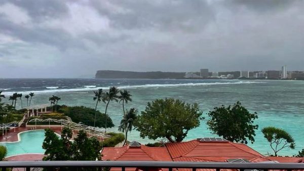
Typhoon Mawar closes in on Guam as residents shelter, military sends away ships

- Update Time : Wednesday, 24 May, 2023, 11:08 am
- 146 Time View

Online Desk: Residents stockpiled supplies, battened down windows and abandoned wood and tin homes for emergency shelters as Guam was buffeted by rains and winds Wednesday from Typhoon Mawar, the strongest storm to approach the U.S. Pacific territory in decades.
The U.S. military sent away ships, President Joe Biden approved an emergency declaration and anyone not living in a concrete house was urged to seek safety elsewhere ahead of the typhoon, which was forecast to arrive as a Category 4 storm but could possibly strengthen to a Category 5. The last Category 5 to make a direct hit in Guam was Super Typhoon Karen in 1962.
Guam Gov. Lou Leon Guerrero said on social media that the emergency declaration will support the mobilization of resources into Guam, which is “especially crucial given our distance from the continental U.S.” Guerrero ordered residents of coastal, low-lying and flood-prone areas of the territory of over 150,000 people to evacuate to higher elevations.
Federal assistance will be needed to save lives and property and “mitigate the effects of this imminent catastrophe,” Guerrero said in a letter to the president requesting a “pre-landfall emergency” for Guam. Officials warned residents who aren’t in fully concrete structures — some homes on the far-flung island are made of wood and tin — to relocate.
Guam is a crucial hub for U.S. forces in the Pacific, and the Department of Defense controls about a third of the island. Rear Adm. Benjamin Nicholson, Joint Region Marianas commander, authorized the evacuation of defense personnel, dependents and employees in areas expected to be affected
All ships were moved out to sea as a standard precaution, according to the Navy, and any personnel remaining on the island were sheltering in place. About 6,800 U.S. service members are assigned to Guam, according to the Pentagon. With rain from the storm’s outer bands already falling over the island as of late morning local time, the typhoon had maximum sustained winds of 140 mph (225 kph) with gusts peaking at 170 mph (274 kph), said Landon Aydlett, a meteorologist with the National Weather Service in Guam. Its center was about 75 miles (120 kilometers) southeast of the island and was moving to the north-northwest.
That was a slight downgrade from earlier when Mawar was reported to be a Category 4 “super typhoon,” meaning maximum sustained winds of 150 mph (241 kph) or greater. But it still posed extreme danger to life and property. The weather service warned of “considerable damage” from a “triple threat” of winds, torrential rains and life-threatening storm surge of 4 to 6 feet (1.2 to 2 meters), with dangerous surf of 20 to 30 feet (6 to 9 meters). It said the storm could hit Wednesday afternoon in the southern part of Guam, which lies west of the International Date Line and is a day ahead of the U.S. mainland and Hawaii. “This is going to be a rough afternoon for us across the island,” Aydlett said. “So watch out.” If Guam doesn’t take a direct hit, it will be very close, said Patrick Doll, the lead weather service meteorologist in Guam. Mawar is a Malaysian word that means “rose,” he noted.
Shool buses picked up residents at island community centers and transported them to 11 elementary schools outfitted as shelters. Civic workers in various villages warned residents to secure loose objects in their yards and seek shelter immediately. Some spread the word by megaphone, while others turned to social media. Power flickered off and on as the rain and wind intensified, and officials said nearly 900 people were in shelters. Guerrero urged residents in a YouTube message to remain calm and ordered the National Guard to help those in low-lying areas evacuate, saying, “We are at the crosshairs of Typhoon Mawar. Take action now.”
The storm was moving at 6 mph (10 kph) but had an eye 17 miles (27 kilometers) wide, meaning people at the typhoon’s center could see calm conditions for over three hours and conclude, far too soon, that the worst is over, Doll said. As the eye leaves, the winds could rise to 150 mph (241 kph) in minutes, so people should remain sheltered until the government gives the all-clear. “Folks may say, ‘Hey it’s over, we could go outside and start cleaning up,’” Doll said. “That is totally wrong.
In low-lying Agat along the southern coast, resident Reuel Drilon began preparing Friday and spent the weekend tying down patio furniture and trash containers. Nearly every home in the village, he said, has a mango tree — which officials warned could be ripped from the ground and become roadblocks and deadly flying projectiles. “A lot of folks are keeping their eyes on trees,” he told The Associated Press. “Down south, we have a lot of coconut trees and mango trees.”
Joshua Paulino, a client manager at Xerox Guam, was sheltering at home in the central village of Chalan Pago with his wife, two sons and mother after the family closed the shutters and secured outdoor objects. He worried that the storm could dump rain on the island for a long time, since it was forecast to pass by gradually. “This storm is moving very slowly so that is making me really uneasy,” Paulino said by text message.
And an ocean away in Los Angeles, Marichelle Tanag was fretting from afar after her parents, who are in their 70s and have survived many typhoons in their decades on the island. They boarded up windows, stocked up on a couple of weeks of food, prepared the generator and filled bathtubs with water. Their home in Tamuning, also in central Guam, is made of concrete, but she worried about it nevertheless. “Will the house stand? … If not, will they be able to go to another place of safety if needed, as fast as possible, and not get in the way of any of the flying debris?” Tanag said by phone.
Rota, an island in the U.S. Commonwealth of the Northern Mariana Islands, was also under a typhoon warning, Doll said. Tinian and Saipan, in the Northern Marianas, were under tropical storm warnings. Some people in those areas are still in temporary shelters or tents after Category 5 Super Typhoon Yutu in 2018, Doll noted.
The western Pacific is “a notorious breeding ground for intense tropical cyclones,’’ said Yale Climate Connections meteorologist Jeff Masters. “They’ve got a much bigger area to romp around in and more time to intensify.” The National Oceanic and Atmospheric Administration has warned that in a warmer world, the number of Category 4 or stronger storms will increase by 10% — and Mawar “could well be a harbinger of the type of battering that the U.S. could expect to see,” Masters said.


