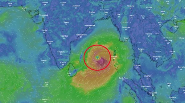
Cyclone ‘Mocha’ likely to make landfall in Bangladesh May 14

- Update Time : Thursday, 11 May, 2023, 10:23 am
- 136 Time View

Online Desk: State Minister for Disaster Management and Relief Mohammad Enamur Rahman on Wednesday said Cyclone Mocha is likely to intensify into a super cyclone. However, meteorologists are predicting by the time it makes landfall, it would most likely take the form of a severe cyclonic storm. The cyclone is likely to make landfall on Cox’s Bazar coast by Sunday (May 14), he said.
The state minister made the remarks at a press briefing at the Secretariat on Wednesday afternoon. Earlier, the state minister held an inter-ministerial meeting to discuss preparations for Cyclone Mocha. “We have predicted that it will intensify into a super cyclone. The wind speed can be upto 220-232 kilometers per hour.” The state minister said the low pressure in the Bay of Bengal is likely to intensify into a cyclonic storm by Thursday. “According to the forecast, the cyclone is likely to make landfall between the evening of May 13 and the morning of May 14,” he said.
The state minister further said the cyclone is now moving towards north and northwest direction citing reports of the forecast agencies of different countries including the meteorological departments of Bangladesh and India. “It is still located an average of 1,500 km south of the coast of Bangladesh. It will turn northeastwards by May 12,” he said.
In fact, according to the Indian Meteorological Department’s latest update, the system intensified into a deep depression over southeast Bay of Bengal during the early hours of Wednesday morning. As of 6:00am on Wednesday, it lay centred about 540 km west-southwest of Port Blair (capital city of Andaman-Nicobar Islands) and 1350 km south-southwest of Sittwe (Myanmar).
IMD said the deep depression is expected to intensify into a cyclonic storm by Wednesday evening. A system is categorised as a cyclonic storm when its 3-minute average maximum sustained wind speeds fall between 63-88 kmph. Cyclone Mocha will then move north-northwestwards over southeast and adjoining central Bay of Bengal, and gradually strengthen into a severe cyclonic storm (wind speed 89-117 kmph) by Thursday morning and then a very severe cyclonic storm (118-165 kmph) by Friday morning.
Thereafter, it will gradually recurve, and start its move north-northeastwards towards the Bangladesh coast. As it does though, it will start weakening by Saturday (May 13), according to IMD. Come Sunday (May 14) afternoon, it will make landfall over southeast Bangladesh and north Myanmar coasts — between Cox’s Bazar in Bangladesh and Kyaukpyu (Myanmar) — as a Severe Cyclonic Storm, with a maximum sustained wind speed of 110-120 kmph, gusting to 130 kmph.


